Mark Zvidzai
Last update: 2 December 2013
Summary
Arid and semi arid environments normally tend to experience serious resource constraints such as water and forage for wild and domestic herbivores(Western 1977).The need to fulfill these biological requirements has been identified as the main driving force of these ecosystems.
In the context of climate change, it is thus critical for rangeland managers to develop cutting edge tools that help them understand the spatial and temporal distribution of these critical resources as their availability tend to have a strong bearing on the distribution of both wild and domestic herbivores.
The development of remote sensing and Geographic Information Systems can provide valuable information towards the understanding of surface water dynamics in both space and time(Jones et al 2006).
Remote sensing allows for the multi temporal mapping and monitoring of both permanent and seasonal water sources which may otherwise be inaccessible or labour intensive using traditional in situ methods of mapping (Alsdorf2007).
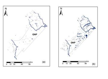
Thus in this study we use remote sensing and Geographic Information System tools to identify and map water resources in the South East Lowveld of Zimbabwe.
Using 24 hour waterhole monitoring of both wild and domestic herbivores at waterholes inside the protected area, at the boundary of protected areas and agricultural areas and in the agricultural areas , we identify hot spots of interaction between wild and domestic herbivores as a preamble for understanding pathways for disease transmission between wild and domestic herbivores. We then discuss the implications for the management of arid and semi arid environments in the context of climate change.
Last update: 2 December 2013


